
When Emergency Response Becomes National Digital Infrastructure
· 3 min read
ABUJA, NIGERIA – When a citizen dials an emergency number, the immediate request is straightforward: help is needed. Yet behind that single call lies a complex operational challenge; how rapidly can a system assess the situation, verify the exact location, deploy the appropriate inter-agency responders, and coordinate an ongoing tactical response?
As public safety requirements evolve, emergency management is moving beyond basic call-taking services. Modern public safety demands a transition from reactive telephone networks to connected, national digital infrastructure.
Closing the Gap Between Signals and Systems
Nigeria’s national emergency short code, 112, managed under the Nigerian Communications Commission (NCC) alongside disaster response frameworks led by NEMA, establishes a critical point of contact for public emergencies. However, answering a call is only the first link in a complex operational chain. Traditional response models often suffer from fragmented handoffs where information is delayed, incomplete, or lost as a call moves from dispatchers to localised police, fire, or medical services.
The future of public safety depends on connecting the digital systems behind the call. When an emergency request enters a connected network, it transforms from a static voice conversation into a dynamic data entry point. A unified architecture instantly captures incident details, cross-references location data, overlays the event onto a Geographic Information System (GIS), and routes actionable intelligence to the correct coordination centres.
The primary objective is not merely answering more calls. It is drastically reducing the time between a request for assistance and the mobilisation of responders.
Spatial Intelligence as an Operational Core
Knowing an emergency has occurred is fundamentally different from knowing precisely where it is happening. Integrating advanced Geographic Information Systems (GIS) changes a digital map from a passive display into an active decision-making tool.
Architectural frameworks, such as the national emergency response models pioneered by public safety infrastructure developers like Giga Forensics, demonstrate how spatial intelligence transforms operations. By placing a central GIS dashboard across all 774 Local Government Areas (LGAs) and linking it to state and municipal coordination centres, decision-makers gain a unified, real-time operational picture.
This spatial awareness reveals nearby response assets, surrounding infrastructure hazards, and active agency resources, allowing dispatchers to make data-driven decisions during critical windows.
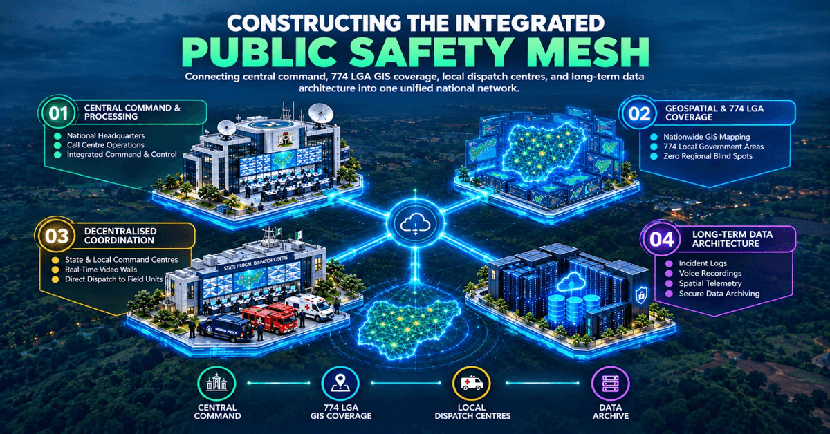
Constructing the Integrated Public Safety Mesh
A connected emergency response ecosystem requires an integrated mesh of telecommunications, data centres, geospatial intelligence, and inter-agency command interfaces.
National emergency infrastructure models illustrate the scale required for this shift:
Central Command & Processing: A national headquarters housing high-capacity call centres supported by dedicated satellite and telecommunications interconnectivity.
Geospatial & LGA Coverage: Comprehensive GIS mapping spanning all 774 LGAs to eliminate regional blind spots.
Decentralised Coordination: State and local command centres equipped with real-time video displays, secure data servers, and direct dispatch links to field vehicles.
Long-Term Data Architecture: Enterprise databases engineered to archive incident logs, voice records, and spatial telemetry for institutional learning and resource planning.
The value of this architecture lies in seamless integration. A call generates data, the data establishes a geolocated record, the record identifies available field assets, and the platform coordinates multi-agency intervention while archiving operational outcomes.
Breaking Institutional Silos in Critical Moments
Emergencies rarely respect administrative boundaries. A major vehicular collision requires traffic management, fire rescue, and medical intervention simultaneously. Similarly, severe climate-related disasters or urban fires demand coordinated action across public safety, disaster management, and municipal healthcare agencies.
A connected digital architecture does not erase the distinct mandates of individual institutions; rather, it provides the connective tissue that allows them to operate from a single, shared operational picture. When information flows seamlessly across institutional lines, response times shorten, resource duplication is eliminated, and tactical clarity is maintained under pressure.
The Shift Toward Predictive Public Safety Infrastructure
As public safety frameworks adapt to complex climate hazards, urban expansion, and industrial risks, emergency management must continuously evolve. Digital emergency networks do more than handle today's active incidents; they build historical datasets that inform future resource allocation.
By analysing multi-year trends in call volumes, response bottlenecks, and incident frequencies, government bodies can proactively place stations, optimise patrol routes, and strengthen municipal infrastructure before crises occur.
Emergency response does not begin when an emergency vehicle arrives at the scene. It begins the millisecond the first digital signal enters the network. For Nigeria and developing markets across Africa, building connected public safety infrastructure ensures that when a citizen calls for help, information moves as fast as the situation demands.